Strategic Jerusalem: A Tour in Photographs
I have spent the last few days in Jerusalem, meeting with Israelis and Palestinians, mostly the latter. I will have more to say in the coming days about some of these meetings, which have been organized by Academic Exchange—one of Lawfare's partners in the Omphalos project—and the Yitzhak Rabin Center. But in this post, I want to annotate a series of photographs I took the other day during a remarkable tour of strategic Jerusalem flashpoints.
I have spent the last few days in Jerusalem, meeting with Israelis and Palestinians, mostly the latter. I will have more to say in the coming days about some of these meetings, which have been organized by Academic Exchange—one of Lawfare's partners in the Omphalos project—and the Yitzhak Rabin Center. But in this post, I want to annotate a series of photographs I took the other day during a remarkable tour of strategic Jerusalem flashpoints.
The tour was given by Ron Shatzberg, a man with the kind of complicated biography this region seems effortlessly to churn out. Shatzberg has been involved in all sorts of Palestinian-Israeli peace initiatives. He is also a reserve colonel in the Israel Defense Forces, who has been involved in combat operations in the Jerusalem area. So he speaks with a combination of deep engagement and sympathy with Palestinian grievances and aspirations and a first-hand sense of the Israeli security challenges associated with addressing those grievances and aspirations.
What follows is not a write up of the tour he gave, which I'm afraid I could not do justice. It is, rather, a series of photographs I took along the way, annotated by me with information drawn from Shatzberg's comments, other sources, and some thoughts of my own. It is designed to be informative, a kind of visual introduction to the strategic problems of Jerusalem for both Israelis and Palestinians. It incorporates several distinct, though interrelated, problems: the holy sites, Jewish settlement in East Jerusalem and in the West Bank, and the very real security problems for Israelis associated with the proximity of Palestinian and Jewish neighborhoods.
It is not possible to write about Jerusalem in an entirely neutral fashion that everyone will accept as unbiased. I am not going to try. My goal here is to be informative, not normative, but in what follows, I'm not going hide my views either. I am writing these words from the King David Hotel, the only hotel I will likely ever stay in that was bombed on orders of a man who later became prime minister of the country in whose capital it sits. The hotel these days is overrun with members of Congress and staff, brought here by an AIPAC-affiliated group in the runup to the Iran deal vote. They will, I suspect, not be visiting the sites where I took some of these pictures—or, at least, they will not see them through the same lens with which I took them. On Friday, a young woman associated with one of the visiting members informed me earnestly in the hotel lobby that, "they have a very important vote coming up next month. I think it will be good for Israel"—as though anyone in this hotel must be fervently praying for the Iran deal to falter and as though it's obvious what is good for Israel. It's a city where a great many people seem to consider the truth (whatever truth they hold dear) as self evident and the justice all on one side.
These photos, conversely, are about complexity: moral complexity and strategic complexity alike.
To understand them, here are two relevant maps of Jerusalem and its environs, the one on top covering a narrower area than the one below. Both maps are from Google Maps and they provide important reference points for the photos, which dramatize both very real and legitimate Israeli security concerns and infuriatingly provocative building in areas that make it far harder to imagine the satisfaction of entirely legitimate Palestinian national objectives.


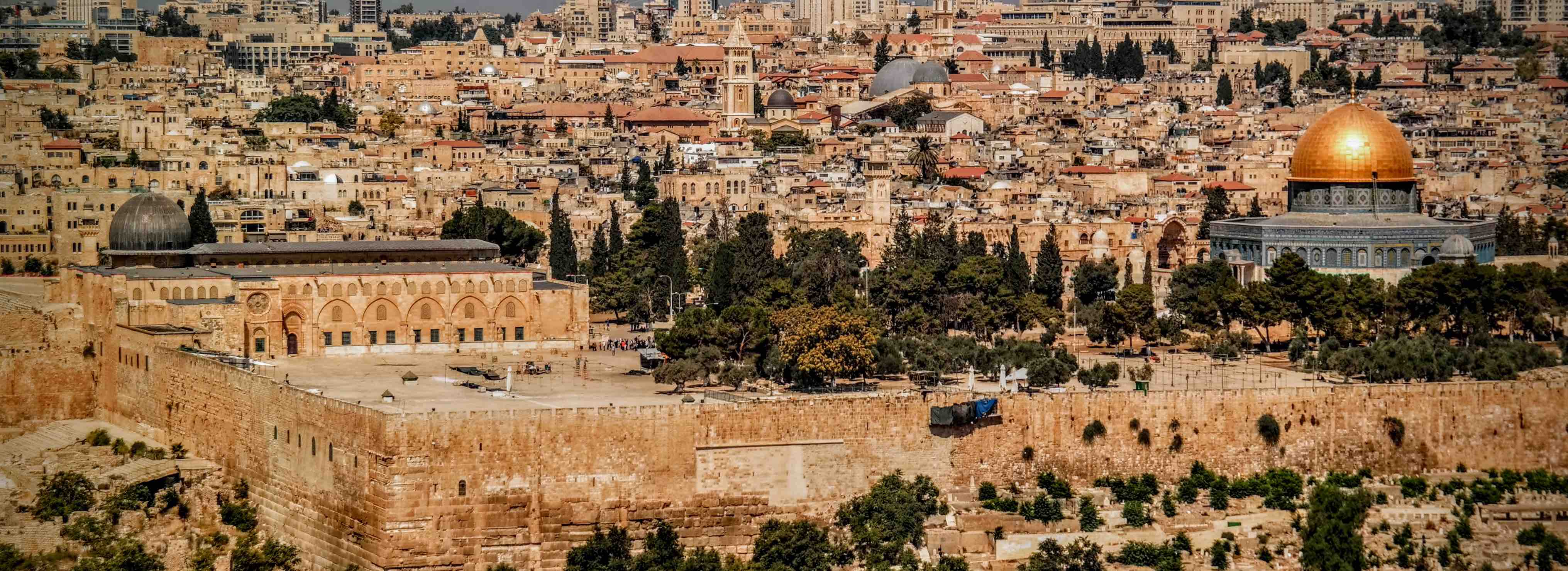
Let's start with the image that is probably most familiar to readers, even those who have never been to Jerusalem. This panoramic shot was taken from the Mount of Olives, directly across from the Old City and the Temple Mount. If you look at the first map, the Old City appears as a distorted rectangle containing the Church of the Holy Sepulchre and the Western Wall, as well as the Muslim holy sites, which are unlabeled in this map but appear as a rectangle in the bottom right hand corner of the larger rectangle. I'm including this image because, for those who need the most basic introduction to the conflict over Jerusalem, it shows the density of contested holy sites in the city's very core.

To orient the uninitiated, the giant gold dome is the Dome of the Rock. To its left, you can see the Al Aqsa mosque. These sites constitute what Muslims worldwide regard as the third holiest site in Islam. Between them, in the distance, you can see the dome of the Church of the Holy Sepulchre, the traditional site of the crucifixion and resurrection of Jesus, which is easier to see in the picture at the top of the page. The Muslim holy sites both sit on a raised platform known as the Noble Sanctuary to Muslims. Jews, however, know this same site as the Temple Mount, the site of the Temple of Jerusalem destroyed by the Romans in the First Century AD—and also the site of the First Temple, destroyed more than 600 years earlier than that. This photo is taken from the East, so you can't see the Western Wall, but the entire site is the holiest in the world to Jews.
There's more. Look just left of the walled city, and you'll see the ruins of what's called the City of David—the most ancient excavated part of Jerusalem. Immediately outside the city walls as you move down the photo are 500-year-old Muslim graves, and as you rise up the Mount of Olives towards the point of view of the photographer (the very bottom of the picture), you cross a Jewish cemetery that has been in continuous use for 2,000 years.
There is no place in the world where it is harder to imagine how to handle political sovereignty and practical governance than within the four corners of this image. Last December, I offered some thoughts on how one might do so. Others have thought about the question much more deeply. For present purposes, suffice it to say that if there were no other photos in this collection, no other issues to discuss, this one alone would make Jerusalem one of the world's hardest and most intractable land disputes in the world to resolve.
Unfortunately, the holy sites are only the beginning of the problem.
This next image is, to say the least, less iconic. Very few visitors to Jerusalem—and I would venture the guess that none of the members of Congress sharing my hotel who are so sure they know what is "good for Israel"—would be able to identify it or its significance. Yet this stretch of land, known in Israeli government planning documents as E1, is important to the question of how whether the two-state solution will remain a viable policy objective for Israelis and Palestinians.

The photo was taken from Mount Scopus, home of the Hebrew University of Jerusalem, facing eastward and looking out over the Judaen hills in the West Bank. If you look at the first map, the Hebrew University sits in an area demarcated by a dotted line to the East of the Old City, and the photo was shot from the eastern edge of the campus area. The road running up the right side of the photo is heading to the Israeli settlement of Ma'aleh Adumim, one of the largest settlements in the West Bank and visible through the haze in the upper right of the photo. To get there, it has to jog around the Palestinian village of Azaryia, which you can see more clearly just above the road. E1 is the large stretch of land that lies between Ma'aleh Adumim and the municipal borders of Jerusalem. It is part of the West Bank, but within the municipal boundaries of the settlement.
The significance of the photograph is that it shows just how important E1 is to the future of Jerusalem and the West Bank. If Israel were to, say, build a lot of Jewish housing in it, it would effectively connect Ma'aleh Adumim to Jerusalem itself. In doing so, it would also go a long way toward cutting off Palestinian neighborhoods in East Jerusalem from the West Bank, thus making East Jerusalem even more implausible geographically than it already is as a capital of a Palestinian state. Perhaps more importantly, connecting Ma'aleh Adumim to Jerusalem would tend to cut the West Bank in two along its east-west axis. The space between Jerusalem (which is about 2,500 feet above sea level) and the Dead Sea (which is not far away but is, at about 1,400 feet below sea level, the lowest point on Earth) involves a very sharp descent. If Israel extended all the way to Ma'aleh Adumim, the effective distance between the major Palestinian cities of Ramallah (just to Jerusalem's north) and Bethelehem (just to its south) would be much greater. Palestinians would have to descend far eastward into the barren desert and then climb back westward to get between towns that are just a few miles apart.
The Israeli government has sought to build in E1 at various times, over strenuous US and European objections. And it's not just right-wing governments that have entertained the idea, which was initially put forth by Yitzhak Rabin.
The photo makes vivid exactly how consequential that would be.
The Palestinians are not being hysterical or paranoid in their deep anxiety and anger about Israeli strategic building. The Israeli history of building Jerusalem out by way of both establishing irrevocable presence and of encircling Palestinian East Jerusalem with neighborhoods inside the city and settlements outside it is a long one. And it's been very effective.
Consider this picture by way of example.

On the left is the Jerusalem neighborhood of Har Homa, built atop a hilltop in the southeastern corner of municipal Jerusalem. (Har Homa is not marked on the maps above but is slightly south of Ramat Rachel, which is marked on the first one.) The building of the neighborhood began over vigorous Palestinian and international objections in the late 1990s. It now houses 13,000 people, and there its talk of expanding it westward in a planned neighborhood that would be called Givat Hamatos in what is now empty space between it and the nearby neighbood of Gilo (Gilo is also not shown but is immediately north of Beit Jala across route 60).
The separation barrier runs immediately next to Har Homa, sealing the neighborhood off from the Palestinian territories. If you look to the righthand half of the image, however, you'll see the outskirts of the city of Bethlehem.

If you build it, they will come—and then you have to protect them. In the West Bank, protecting them has involved building a whole network of roads Palestinians are not allowed to use. It has meant checkpoints and a great deal of restriction on Palestinian mobility and land use. It has meant deep and pervasive inequality. In Jerusalem, where Palestinians are subject to Israeli civil law—not the occupation authority—it has meant something else: the slow steady shrinkage of the area they imagine as their capital and disconnection from one another of neighborhoods that need to be contiguous for East Jerusalem to make any sense as an entity of its own.
Particularly if you imagine the Har Homa neighborhood expanded to the west to meet up with, or approach, Gilo, the map of a Palestinian state with East Jerusalem as any kind of capital becomes harder—not impossible but harder—to draw. At some point, if you keep building, the maps simply no longer work.
Walling in Jerusalem by building new neighborhoods is an explicit policy goal of many figures on the Israeli right. But the mantra of a unified Jerusalem is a matter of all-too-broad political consensus in Israel. And many politicians who do believe in negotiated solutions have, at the same time, either acquiesced in or actively embraced strategic building in Jerusalem and its environs. It is important to understand both how these projects narrow the space for possible negotiations and how they really squeeze Palestinian life in practice.
But lest you think the problem of Jerusalem is exclusively, or even chiefly, a problem of Israeli building, consider this picture, taken from the edge of the Jewish neighborhood of Gilo. I took this photo from immediately in front of outer rim of housing in Gilo, which stands a no more than a few meters behind the point of view of the camera. The view from that site overlooks the Palestinian neighborhood of Beit Jala, on the outskirts of Bethlehem.

Notice the road on the right, and the apartment buildings immediately to its left. The photo below offers a closer look at that segment of the landscape. During the last intifada these apartments were used to conduct sniper attacks on traffic on the road. Machine gun fire was also routine across the valley towards the housing at Gilo. Israel was initially unable to respond robustly to the attacks from these apartments because Beit Jala lies in Area A—an area designated by the Oslo Accords as subject to full Palestinian control. Shatzberg was actually the brigade commander responsible for dealing with the seam between Gilo and Beit Jala. He describes his frustration when he sought permission to take the hill on which the apartment buildings sit—and from which the gunfire was coming—and was turned down on grounds that he could not enter Area A.

More generally, the proximity of Israel to Palestinian-controlled areas along the long edge of the West Bank made it easy for Palestinians in the territories to cross into Israel and conduct suicide bombings and other attacks. More than 1,000 Israelis died in these attacks between 2000 and 2005, the overwhelming majority of them civilians.
You can’t really blame these murderous paroxysms on Israeli strategic building. They had a logic of their own. No country would have tolerated them. And Israel didn't. The prohibition against entering Area A fell.
The odd-looking flaps now overhanging the road are designed to shield it from bullets. Gilo windows facing Beit Jala now sport bulletproof glass. The tower in the center of the top Gilo photo houses a camera that conducts 24 hour surveillance into Beit Jala—one of hundreds that now watch deep into Palestinian neighborhoods abutting. And more generally, the so-called “wall”—the huge network of concrete barriers and fencing—now separates the West Bank from Israel and municipal Jerusalem. Along with a number of other policy changes, these changes have had a significant impact. Terrorist attacks have plummeted. Normalcy, or at least what passes for it here, has returned to Israel.
On Friday, I walked through the Mahane Yehuda marketplace. It was jammed, teaming with people pressed so close together you could sometimes hardly walk. I was walking with a world-renowned international relations theorist, who said grimly that if he were a terrorist, this is where he would conduct a suicide bombing. He did not know that, in fact, the Mahane Yehuda market was the subject of just such an attack in 1997. Seventeen people were killed and more than 150 were wounded. In 2002, terrorists struck again, killing seven and wounding more than a hundred. The fact that the market these days is teaming with people buying food in advance of the Sabbath—people who do not feel unsafe there—is a remarkable accomplishment.
But it's an accomplishment that has come with enormous human costs.

Those costs look like this.
Walls are always an ugly thing. But the security barrier is an interesting one in the history of walls because its ugliness has an entirely different flavor depending on which side of it you are on. From the Israeli side, the wall looks like a regrettable necessity—like the wall that surrounds a gated community in a dangerous neighborhood. One would love to not need it, but it also protects. It's a big part of the reason people feel safe shopping at Mahane Yehuda. And people remember what life was like without it. From the other side, however, it’s a prison wall. If you're a Palestinian on the other side of it, it's there to contain you. From an Israeli perspective, it's meant to keep people out. But from a Palestinian perspective, it keeps people in—including the overwhelming majority of Palestinian residents who are just trying to live their lives. It is yet another instrument of Israeli control.
And it does not just separate Israelis from Palestinians. It also separates Palestinians from Palestinians. Consider the image below of a long stretch of the barrier taken from a hill in East Jerusalem that is not marked on the maps above. The neighborhoods on both sides of the wall in this photo are Palestinian, one within municipal Jerusalem and one outside it. There are a lot of photos you could take like this all over the Jerusalem area. In some places, the barrier actually separates East Jerusalemites from each other—running between areas of East Jerusalem and leaving legal Israeli residents walled off from the country in which, according to the government that built the wall, they live. There is simply no way to build a wall separating Jerusalem from the West Bank without profound disruption to Palestinian communal life and without putting some neighborhoods on the wrong side of the wall.
 And there probably is no way to convince Palestinians either that this wall is a protective necessity. It doesn't, after all, protect them. And similarly, Israelis with recent memories of buses blowing up on a regular basis understandably don't look at these ugly images and see the Berlin Wall—which nobody on either side of Berlin ever doubted existed to imprison East Berliners, not to protect anyone in the West. Many Israelis also don't see, or don't care, how much their own government's campaign of strategic building has exacerbated the problem. Any separation barrier will necessarily separate Palestinian communities from one another. But the barrier's route is all the more tortured because of the need to protect neighborhoods that needn't be there—both inside Jerusalem and elsewhere.
To bring this full circle, consider one final image: a photo I took from the same spot as the one above. The image above is what you see if you look eastward from this spot. The image below is what you see if you look westward. The point is that the distances in question are really short. From the security barrier to the Dome of the Rock is a matter of line of sight, and not just line of sight for people with particularly keen eyes either. People who have not spent time in this city sometimes have a hard time understanding why building on some dusty hilltop matters, on the one hand, or why Israelis feel so constrained by fear of terrorism, on the other. These two pictures in relation to one another are part of the answer to that question. It's a very small space, and every square inch of it matters.